
Geodesic surveys carried out during the road and transport building of the M 12 highway section in Bashkortostan
Геодезические изыскания в процессе дорожно-транспортного строительства участка автомагистрали М-12 в Башкортостане
The priority area for the development of Russia’s transport infrastructure is the construction of speed highways. This article focuses on the engineering and geodesic support for the road construction of a section of the federal highway M‑12. The 140 km long “Dyurtuli – Achit” section of the four‑lane M‑12 motorway runs through the north‑west of Bashkortostan. The design and construction of main highways are preceded by geodesic surveys, which include: reconnaissance studies; detailed engineering and technical development of the highway project and transport structures; and the preparation of working drawings. During the construction of the M‑12 federal highway section in Bashkortostan, geodesic instruments and equipment were used: a theodolite, a level, tacheometer, a global navigation satellite system, a laser scanner, aerial photography equipment, and others. One of the main tasks of geodesic surveys in the course of road and transport construction is to create accurate topographic maps of the area, which are necessary for designing highways, determining the optimal route, and calculating the volume of work. Among the promising trends in the development of geodesic surveys in road and transport construction, it is worth noting highly intelligent robotic systems that can independently carry out three‑dimensional surveying of the roadway terrain and analyze data using artificial intelligence. For the smooth operation of the intelligent transport infrastructure of the M‑12 “Vostok” highway with a permitted speed of up to 120 km/h, a complementary and accurate reproduction of the highway’s geometry, road signs, markings, etc., is required. Engineering and geodesic surveys of the M‑12 highway section in Bashkortostan lay a solid foundation for the safe and cost‑effective operation of the road and transport infrastructure.
transport infrastructure, geodesic survey, tacheometer survey, highway.
The building and reconstruction of speed and quality highways are priority areas for the development of the transport infrastructure of the Russian Federation. To address the pressing issues in road and transport building, engineering and geodesic surveys of highway route routes are required [1, 2]. Geodesic surveys in the area of highways under construction provide reliable data on the terrain, relief, and existing artificial structures.
The purpose of this article is to examine the engineering and geodesic support for the road building of the “Dyurtuli – Achit” section of the speed federal highway M‑12 “Vostok”.
The “Dyurtuli – Achit” section of the four‑lane IB category M‑12 highway, 140 km long, runs through the north‑west of Bashkortostan (Dyurtyulinsky, Buraevsky and Tatyshlinsky districts). The new section of the Dyurtuli – Achit road part of the high‑speed route from Moscow to Yekaterinburg, is a continuation of the M‑12 “Moscow–Kazan” highway and begins at the interchange with the 1221st km of the M‑7 “Volga” road (near the city of Dyurtuli). The expressway crosses swampy lowlands, uplands, and river valleys (including the Belaya River near the village of Vostretsovo in the Buraevsky District).
The relief of the Dyurtyulinsky and Buraevsky districts of Bashkortostan is gently undulating, dissected by the valleys of the lower reaches of the Belaya River and its tributaries (Bystryy Tanyp) within the Pribelskaya hummocky‑rolling plain. The landscape of the Tatyshlinsky district is hummocky; there are low, level interfluves, as well as individual elevations (asymmetric ridges that are dissected by gullies and ravines). From the perspective of road and transport building, this segment of the highway is among the most challenging due to the diverse geotechnical conditions involved in building a high‑quality road surface, dozens of road bridges, elevated overpasses and other transport structures (Figure 1).
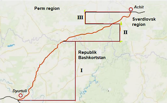

Figure 1. Layout diagram of the “Dyurtuli – Achit” section of the M‑12 highway
(I – 140 km; II – 92 km; III – 43 km)
In some lower sections of the route, sinkholes and karst lakes are found, which is due to the characteristics of the underlying rocks (permian limestones, etc.). Therefore, during the design process, it was necessary to bypass swampy and karst areas, which increased the volume of earthworks. The route of the “Dyurtuli – Achit” section in Bashkortostan passes, among other things, through specially protected natural areas and oil and gas fields, bypassing settlements and archaeological sites, which also imposed additional restrictions. The necessary connection to the transport infrastructure of existing roads will be provided via two transport interchanges: the first is located at 68 km of the new highway, at the intersection with the regional road “Ufa–Birsk–Yanaul”, and the second is at 127 km, at the intersection with the regional road “Buraevo–Starobaltachevo–Kueda”.
The building of main highways is preceded by a set of geodesic surveys, which include: reconnaissance studies for the technical and economic justification of the project; detailed engineering surveys to develop the technical design of the highway and transport structures; and the preparation of working drawings. The smoothness and safety of traffic at specified speeds on highways are strictly regulated by maximum (guiding) slopes and minimum curve radii. In the context of actively developing transport infrastructure and geo‑urbanization, design surveys in the road building industry are becoming particularly important [3].
In the process of designing and constructing the federal highway M-12 [4] section of the route in Bashkortostan, geodesic instruments and equipment were used to improve the efficiency and quality of engineering and geodetic surveys: a theodolite, a level, a total station, equipment for the global navigation satellite system, a laser scanner, aerial photography equipment, a cable tracer; unmanned aerial vehicles, satellite navigation methods, and others were also used. Aerial photography data, processed using digital software modules, make it possible to promptly adjust the road and transport building process. The result of the engineering and geodesic surveys is a topographic plan of the area, showing the relief and the existing situation (including real estate objects such as buildings, power lines, etc.).
At the same time, the main tools for engineering and geodesic support of the road construction process remain tacheometers (total stations) for measuring angles, distances, and coordinates of points. In tacheometric surveying at scales (1:500–1:5000), the planned position of highway points is determined using the polar coordinate method, while the elevation is determined by trigonometric leveling using an inclined beam. Field geodesic surveys in the process of tachometric surveying (Figure 2) begin with reconnaissance of the terrain, i.e., with an inspection of the landscape and the creation of a planimetric and elevational framework.
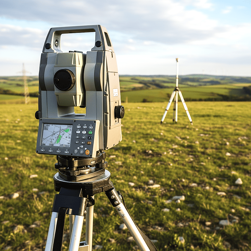
Figure 2. Tacheometric survey of the highway building site
Currently, traditional methods of geodesic surveys in the process of road and transport building (tacheometric surveying to obtain a topographic map of the area, leveling) are being supplemented by satellite technologies for creating networks and referencing; laser scanning and the use of unmanned aerial vehicles for detailed 3D models, etc. An electronic tacheometer is a highly accurate modern geodesic instrument that consists of an angle‑measuring part, a rangefinder, and a built‑in computer. Digital technology for designing highways makes it possible to construct a three‑dimensional model of the terrain, which is created on a computer and obtained through continuous total station surveying or laser scanning. Tracing is a set of engineering and technical works aimed at obtaining the optimal route option in relation to the terrain and relief.
The road and transport building of the “Dyurtuli–Achit” section of the M‑12 “Vostok” highway in Bashkortostan began in 2022; in July 2025, the high‑speed highway was put into operation. The speed highway, with a permitted speed of up to 120 km/h, includes: 50 overpasses, 6 transport interchanges, 25 road bridges, 24 eco‑overpasses and bi‑transits for animals, which will help improve traffic safety. The key components of the automotive transport infrastructure of federal highways are roads with two or more lanes in each direction, featuring barrier separators between traffic flows; bridges, transport interchanges, noise‑reducing screens, mobile communication towers, multifunctional roadside areas with gas stations, etc. Category I roads (with an estimated traffic volume exceeding 14000 vehicles per day) best meet the conditions for optimized automotive traffic.
The building and commissioning of the high‑speed M‑12 motorway along one of the busiest routes in the country – from the central part of Russia to the Urals – will lead to a shift in traffic away from the overloaded federal highways M‑7 “Volga” and M‑5 “Ural”. Speed highways have asphalt concrete pavement, wide lanes (3.75 m), increased turning radii and limited maximum gradients (3–4 %), as well as wider shoulders. Such road structures ensure high throughput and optimized safety for round‑the‑clock traffic; in winter, snow removal is carried out and the road surface is treated to prevent icing. The ensemble of interconnected infrastructure transport facilities includes speed highways; technical services of the road infrastructure; various buildings for operation; road service facilities; and other auxiliary structures.
The project for the “Dyurtuli – Achit” highway section in Bashkortostan provides the construction of more than 105 artificial transport structures, including five transport interchanges, as well as the relocation of utility lines and the stabilization of soil foundations [5]. Despite the variety of engineering transport structures on the Dyurtuli–Achit section of the M‑12 highway, the following tasks are addressed during their design and building: obtaining geodesic data when developing construction project designs (engineering and geodetic surveys); determining the main axes and boundaries of structures on the ground in accordance with the construction project (layout works); ensuring that the geometric shapes and dimensions of the elements of the facilities comply with the project during building, etc. Geodesic control includes checking elevation marks, monitoring the location of transport structures, and measuring the profiles of the highway [6].
It should be noted that engineering and geodesic surveys in road and transport construction provide accurate data on the relief of the landscape for the design, building, and reconstruction of roads. Geodesic support makes it possible to: develop topographic and geodetic materials to substantiate design solutions; select the optimal route for the highway, taking into account natural landscape conditions; ensure the required accuracy from the layout in the field to monitoring during the building of a speed highway; reduce the risks of operational deformations and, subsequently, guarantee the safety of traffic.
Geodesic surveys related to laying out a highway on the ground involve the following operations: assigning lines of a given direction and slope, measuring or marking turning angles, marking and securing the route, marking curves at turning angles; dividing the entire route into 100‑meter segments (pickets); leveling to determine the elevations of points located along the route in hard‑to‑reach areas and to select locations for the future building of road transport facilities.
The regulatory framework for geodesic surveys is GOST 32869-2014 “Automobile roads of general use. Requirements for carrying out of topographic-geodetic researches.” According to GOST 32869, the following stages of geodesic surveys are distinguished:
♦ preparatory work (collection and analysis of old topographic maps based on archival materials, desk‑based tracing of route options, engineering of a geodesic work program, and selection of geodetic equipment);
♦ field work (creation of a planimetric and elevational geodesic framework (reconnaissance, securing benchmarks and network points); topographic surveying of the area along the route (scale 1:5000–1:500); field tracing: marking and securing route points (turning angles, picketing, etc.); leveling of the route and profiles; detailed tachymetric surveying: terrain; inspection of existing engineering structures (bridges, pipelines, etc.);
♦ desk-based (processing of field data: compiling engineering and topographic plans, profiles, and a digital model of the landscape terrain; preparing a technical report for the client). The digital terrain model can be represented as a combination of individual digital models (layers): landscape relief; situational features; soil and ground conditions, hydrogeological, engineering geological, and hydrometeorological conditions; technical and economic indicators; and other characteristics of the terrain.
Among the many tasks solved using digital models, it should be noted: optimal spatial tracing of highways; obtaining longitudinal and transverse engineering geological sections along the axis of the route; obtaining initial engineering and hydrological information for the design of culverts; solving the problem of land mass distribution and vertical layout; spatial modeling of the roadway and ensuring the requirements environmental safety of the surrounding landscape [7]. The appropriate layout of the elements of the cross‑section of the roadbed involves marking on the ground, in plan and in height, all the characteristic points of the cross‑section of the roadbed: the carriageway, the shoulders, the slopes, the culverts, the base of the embankments, etc.
In addition to the usual tacheometers accepted for use to replace theodolites, others currently, in the process of geodesic surveys in road transport building, innovative electronic robotic measurement systems based on GPS (GLONAS antennas and 3D laser scanners [8, 9]) have been developed and are being used. A modern geodesic GPS receiver consists of three main elements: the receiver itself – the main device that receives information from satellites, processes it, and records it in memory (or to an external device); the antenna – the receiving element; the controller – a device that allows you to control the operation of the receiver. It should be noted that after western countries, imposed sanctions restrictions on the Russian Federation, high‑precision imported electronic total stations became difficult to obtain [10].
In article [11], the authors developed methods for using electronic tacheometers to determine the slope steepness of the roadbed and the visibility distances of the road and oncoming vehicles on vertical curves; as well as to determine the actual geometric parameters of highways when assessing the quality of road and transport building. It should be noted that even when using the latest equipment, the quality of geodesic survey materials in terms of accuracy and informativeness is limited by other factors of a technological and organizational nature inherent in highway construction [12]. Therefore, to establish optimal requirements for the accuracy of geodetic work at all stages of a highway’s life cycle, the justification for the accuracy requirements for geodesic work must be linked to changes in the standards for the accuracy of geometric parameters, using a systematic approach.
It should be noted that all geodesic and geoinformation works performed using unmanned aerial vehicles, topographic aerial photography, and laser scanning require accuracy (up to 2 cm in height, 5 cm in plan) and equipment (certified geodetic modules) in accordance with regulatory documents: GOST R 56122-2014, GOST R 57258-2016, GOST R 59328-2021, GOST R 59517-2021, GOST R 71886-2024, as well as the code of rules of CR 317.1325800.2017 «Engineering and geodetic surveys for building. General rules for carrying out work”.
Global navigation satellite systems play a key role in modern geodesic monitoring of road and transport building of highways. The main advantages of global navigation satellite systems are: they allow measurements to be taken in remote and hard‑to‑reach areas; high accuracy in determining coordinates, with deviations of up to 1–2 millimeters; independence from weather conditions; and the speed of measurements. It should also be noted that several rovers (mobile receivers) can operate from a single base station of a navigation satellite system, which makes it possible to carry out layout work simultaneously and manage the optimal operation of road building equipment.
One of the main tasks of geodesic surveys in the course of road and transport building is to create accurate topographic maps of the area, which are necessary for designing routes, finding the optimal route, and calculating the volume of work. Multicopters – unmanned aerial vehicles built according to a helicopter design, with 4–8 main rotors [13] – are widely used in geodesy for creating topographic maps; they collect information about the landscape and structures within a given area. Multicopters are highly maneuverable, which makes them ideal for working in confined spaces and for collecting detailed data on localized objects and creating an orthophotomap (a geometrically corrected digital image of the terrain, created based on aerial photographs of the landscape) (Figure 3).
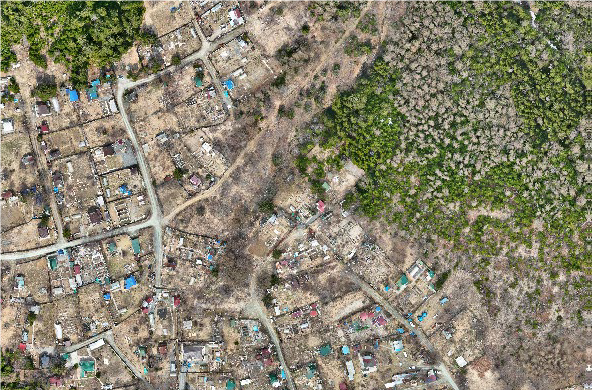
Figure 3. Orthophotomap of the area near the future highway
Satellite receivers, as high‑precision tools in geodesic control of road and transport building, provide a clear planimetric and elevational reference for both axial and off‑axis points of highway bridge structures. The base station, equipped with a radio modem, is installed on the highway section under construction. The rover receiver, with a GPS antenna on a mast and a radio antenna, is mounted on the road construction machine. Even in unfavorable conditions, the grader’s position can be monitored with an accuracy of 2–3 cm, and the accuracy of height measurements, which are carried out using laser equipment, is ±2–3 mm. Modern road building machines equipped with geodetic equipment significantly increase the speed of planned work and the accuracy of the implemented design solutions.
Engineering and geodesic surveys in road construction under winter conditions are carried out taking into account: snow cover, ground freezing, low temperatures, and short daylight hours. In winter, the micro‑relief may be hidden by the snow cover, so partial clearing is often required; it is permissible to carry out surveying when the snow depth is no more than 20 cm. Tacheometric surveying (with an electronic tacheometer) under winter conditions is carried out in the form of a prismless survey (over short distances), and the stability of the tripod on frozen ground is carefully monitored. Data from ground-based laser scanning make it possible to separate “snow” from “relief” based on the density of the point cloud and to build a digital terrain model adjusted for the thickness of the snow cover.
The integration of traditional geodesic and the latest electronic methods makes it possible to create comprehensive digital terrain models, which become the basis for design in a computer‑aided design environment and subsequent geodetic support for road and transport construction [14, 15]. Modern electronic total stations are integrated optical‑information systems for obtaining geodesic information, on the basis of which digital terrain models are created. One of the directions for developing geodetic measurement methods is the creation of software that makes it possible to combine data obtained using the global positioning method and data obtained with electronic total stations. During the building of the subgrade and road structure of the motorway section, operational geodesic control was necessarily carried out (Table 1).
Table 1
Geodetic operational control of road and transport building of the M‑12 highway section in Bashkortostan
| Type of work | Controlled parameter | Deviation (GOST 33324-2015) | The method used |
| Construction of the earthwork | Deviation of surface elevations from the design values | ± 50 mm | Leveling of the rods every 20 meters |
| Soil compaction | Layer thickness | ± 20 mm | Tacheometric surveying |
| Laying the bottom layer of the base | Height deviation | ± 15 mm | Leveling with spirit levels |
| Laying the top layer of the coating | Surface smoothness | ≤ 3 mm | Measuring the rack clearance |
Among the promising trends in the development of geodesic surveys in road and transport building, it is worth noting highly intelligent robotic systems that can independently survey the terrain along a highway and analyze data using artificial intelligence [15-17]. In addition, digital modeling technologies are being used more extensively; they make it possible to create virtual copies of objects before the construction of highways begins, which allows engineers and designers to plan work more accurately and avoid errors at early stages.
Competent mastery of traditional methods of geodesic surveys and the ability to work with conventional geodetic instruments (orientation, measuring line lengths, measuring horizontal and vertical angles with theodolites; measuring elevations between picket points with levelers, performing topographic surveys, etc.) allows one to quickly master various types of aerial photography, methods of ground photogrammetry and electronic total station, satellite navigation methods, as well as technologies for automated processing of field measurement results. This will significantly reduce the cost of geodetic support for the road and transport construction processes on the M‑12 highway section (Figure 4).
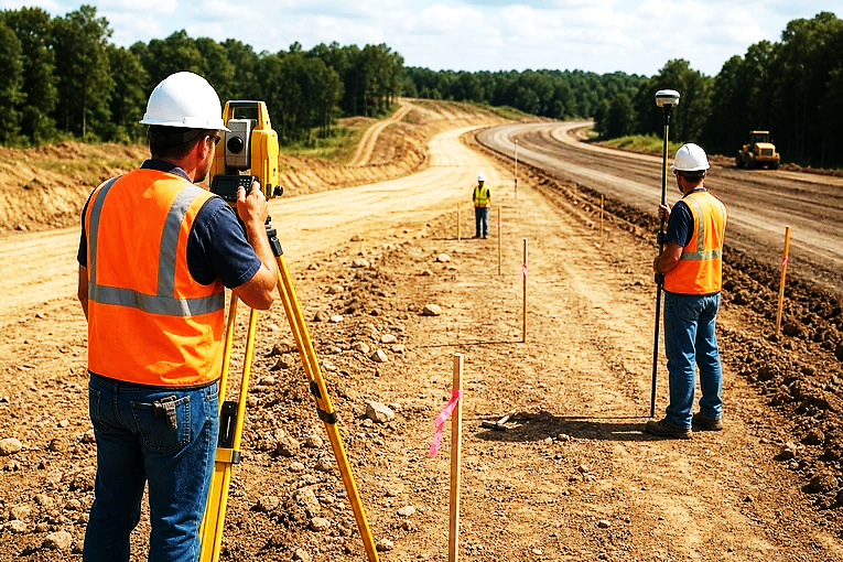
Figure 4. Performing topographic surveys
Recently, to ensure traffic safety on speed highways, landscape design is being implemented. It involves smoothly connecting the elements of the highway and harmoniously combining it with the surrounding environment. In addition to the plan and longitudinal profile, it requires the creation of a terrain perspective and a landscape‑architectural plan [18, 19]. For landscape design, additional aerial photography (perspective, panoramic, colour) and ground‑based stereophotogrammetric surveying of complex road sections are carried out during the survey process.
It should also be noted that engineering and geodesic measurements are carried out directly on the landscape in various physical and geographical conditions, so it is necessary to take care to protect the ecosystem of the surrounding environment: to prevent damage to forests, agricultural lands, and pollution of water resources. In real‑world terrain conditions, it is simultaneously difficult to meet the requirements for the plan and profile, as it is necessary to “bend” the highway to bypass populated areas and other obstacles of urban infrastructure, as well as areas with steep relief slopes and unfavorable geological and hydrogeological conditions.
One example of the use of engineering and geodesic surveys is the construction of road bridges along the M‑12 highway section in Bashkortostan: before starting the work, a detailed tacheometric survey of the area is carried out to determine the optimal location for the supports and spans. Many factors are taken into account: the water flow speed, the height of the banks, and the geological features. When choosing the location for the construction of the road bridge, the navigation conditions and the features of the bank relief were taken into account. In addition to the 814‑meter‑long bridge over the Belaya River near the village of Vostretsovo (Figure 5), the M‑12 highway section crosses other smaller rivers, and each water crossing requires its own engineering solutions.
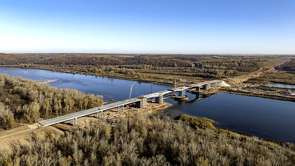
Figure 5. Building of a road bridge across the Belaya river near the village of Vostretsovo, Buraevsky district, Bashkortostan.
The most common soils in the low‑lying riverine areas of the M‑12 highway section in the north‑western regions of Bashkortostan are clayey dispersed soils, the negative feature of which is a sharp decline in their physico-mechanical characteristics when moistened, which significantly reduces the possibility of using them in road and transport construction. To increase the load‑bearing capacity and reduce deformations of the soil bases of major highways, various methods of geotechnical consolidation of dispersed soils are available. The introduction of lime‑containing binders based on large‑scale waste from Bashkortostan into clayey dispersed soil increases its water resistance and mechanical strength [20, 21] of roadbed foundations and reduces the costs of producing road construction materials for speed federal highways by 25-30 %.
One of the leading innovative trends in road construction in the 21st century is the enhancement of environmental friendliness; a promising trend in the implementation of the Russian Federation’s national project “Infrastructure for Life” is the reuse of large‑tonnage waste. The construction of highways and infrastructure transport facilities requires large volumes of gravel, crushed stone, and other stone materials; in the near future, road and transport construction may become a significant consumer of large‑tonnage technogenic waste [22, 23].
By 2030, it is planned to extend the unmanned corridor on the M‑12 “Vostok” highway from Kazan to Yekaterinburg, involving additional geodetic surveys. To implement this project, a fully functional intelligent transport infrastructure is being created to ensure control over the operation of unmanned transport [24] on the M‑12 motorway by leading mobile and fiber‑optic network operators. The use of level-5 unmanned trucks (without drivers in the cab) is possible thanks to the introduction of an experimental legal regime for vehicles and an automated traffic management system. The comprehensive project to integrate virtual modeling of the intelligent transport infrastructure of the M‑12 highway with the actual movement of unmanned vehicles paves the way for the mass adoption of autonomous logistics by 2035.
For the smooth operation of the intelligent transport infrastructure [25] of the M‑12 “Vostok” highway, with a permitted vehicle speed of up to 120 km/h, it is necessary to ensure complementary and accurate reproduction of the road geometry, road signs, markings, and engineering facilities based on geodetic surveys. The smart system integrates data from sensors with artificial intelligence of the road surface, weather stations, video cameras, and GLONASS satellite navigation to create a real‑time updated model of the traffic situation. Unmanned trucks receive information about the condition of the M‑12 highway, traffic density, and potential obstacles via 5G networks.
The successful implementation of the transport strategy of the Russian Federation in Bashkortostan is linked to comprehensive geo‑urban planning for the development of the economic and logistics infrastructure of the regions and republics between the Volga and the Urals. The growth in domestic tourism volumes [26], as well as the tourist attractiveness of the regions of the Ural federal district, ultimately makes it possible to enhance transport accessibility and mobility, as well as to accelerate the development of various types of health‑improving tourism in the recreational complexes of the Republic of Bashkortostan.
In conclusion, it can be stated that engineering and geodesic surveys conducted during the building of highways lay a solid foundation for the safe, comfortable, and cost‑effective operation of the road transport infrastructure of the M‑12 speed motorway section in Bashkortostan.
References
1. Kochetova E.F. Engineering geodesy in road building. Nizhny Novgorod: NNSABU, 2016. 92 p. EDN QZLPCM.
2. Chudinov S.A., Sharov A.Yu. Engineering geodesy and engineering geodetic support for the building of highways. Yekaterinburg: Publ. USFTU, 2023. 211 p. EDN WXRXCB.
3. Shestakov N.I., Fedyuk R.S., Chertes K.L. Assessment of the level of impact of road construction facilities during design // Bulletin of the engineering school university. 2024. No. 2(59). P.119-126. EDN RZZTHH.
4. Khalikov R.M., Ivanova O.V., Pavlov S.Yu. et al. Innovative technologies in the construction of the Dyurtuli–Achit section of the M‑12 federal highway // Trends in science and education. 2024. No.108‑13. P.62-65. EDN SKRIKH.
5. Glazachev A.O., Pavlov S.Yu., Ivanova O.V. et al. Stabilization of weak soil foundations for highways // Trends in science and education. 2024. No.109-15. P.27-30. EDN IYXTMM.
6. Pronina L.A., Stolbov Y.V., Uvarov A.I. et al. Substantiated and interrelated technical tolerances needed in regulatory documents on the construction of roads and their geodetic support // Internat. Conf. "Complex Equipment". Saint-Petersburg: Institute of Physics Publishing, 2019. V.1384. P.012043. EDN WXLXNY.
7. Moshkov V.B., Tskhovrebov E.S., Kalaeva S.Z. et al. Analysis of violations of environmental requirements on highways that lead to threats of emergency situations // World of Transport. 2024. V.22, No.1(110). P.86-92. EDN JNJWFM.
8. Stolbov Yu.V., Stolbova S.Yu., Pronina L.A. et al. Research into the accuracy of the elevation position of a road surface using various geodesic instruments // Bulletin SibADI. 2018. V.15, No.1(59). P.97-105. EDN YTMCNJ.
9. Ivasyk D.V., Vasilchenko A.A., Kokarev K.V. Innovations in modern geodesy in road and airfield building // Engineering bulletin of the Don. 2018. No.2(49). P.163. EDN YATGBF.
10. Katkalo Yu.A., Tuluevsky N.V., Drozdov D.N. et al. Application of electronic total stations for quality control of work in the construction of highways // Bulletin of the Belarusian‑Russian University. 2015. No.3(48). P.143-151. EDN UIBGAT.
11. Ivanova O.V., Glazachev A.O., Khalikov R.M. et al. Efficient operation of road transport during the construction of a four‑lane section of the M‑12 speed highway // Modern prospects of science and technology: Coll. of the 3rd Internat. Conf. Voronezh: Publ. “Universitet. book”, 2025. P.164-167. EDN BRKUBU.
12. Sholomitsky A.A., Kosarev N.S., Nikonov A.V. et al. Study of the accuracy of measuring lengths using laser rangefinders of electronic tacheometers // Bulletin of the Siberian State University of geosystems and technologies. 2024. V.29, No.5. P.59-68. EDN KYIJVF.
13. Baglikova T.E., Popov B.A., Kostylev V.A. Analysis of the use of unmanned technologies in geodesy // Environmental management and nature use of geolandscapes. 2022. No.2. P.22-25. EDN CEKZHD.
14. Paveleko A.A. Technologies for designing highways based on computer‑aided design systems // Bulletin IMSIT. 2023. No.1(93). P.53-56. EDN PGBBPF.
15. Ivanova O.V., Glazachev A.O., Pavlov S.Yu. et al. The demanded application of artificial intelligence in traffic management on the Dyurtuli–Achit section of the M‑12 highway // Prospects of technologies: Coll. 3rd All‑Russian Conf. Voronezh: Publ. “Universit. book”, 2025. P.167-170. EDN FXSQLT.
16. Zubarev V.A., Oznemets V.V. Comparative analysis of the practical application of a total station and a ground-based laser scanning system in a geodesic control // Spatial data: science and technology. 2025. V.16, No.4. P.79-93. EDN IWEJVH.
17. Ivanova O.V., Pavlov S.Yu., Glazachev A.O. et al. Effective operation of intelligent transport infrastructure in the operation of vehicles on speed highways // Modern technologies and innovations: Coll. 2nd Intern. Conf. Voronezh: VSTU, 2026. P.174-177. EDN RXVZJG.
18. Zimina Ya.S., Shchegoleva N.V. Landscape design – a modern approach to the building of highways // Resource‑energy‑efficient technologies in the regional construction sector. 2014. No.4. P.386-389. EDN TJCAVD.
19. Jang W., Lee S.K., Heon S. Sustainable performance index for assessing the green technologies in urban infrastructure projects // Journal of Management in Engineering. 2018. V.34. No.2. P.41-68.
20. Glazachev A.O., Pavlov S.Yu., Shaykhullin I.R. et al. Resource‑saving methods for strengthening weak soils in the bases of road surfaces of highways // Trends of science and education. 2024. No.105‑13. P.10-13. EDN NZOMXA.
21. Latypova Z.B., Khalikov R.M., Glazachev A.O. et al. Geoecological aspects of using lime‑containing large‑scale soda production waste in Bashkortostan // Problems of region ecology. 2023. No.4. P.68-72. EDN ZFOTOL.
22. Slobodchikova N.A., Klyuev S.V., Plyuta K.V. et al. The use of industrial waste in strengthening roadway soil // Proceed. of the St. Petersburg Transport University. 2024. V.21, No.4. P.775-786. EDN MGHOTL.
23. Khalikov R.M., Pavlov S.Yu., Glazachev A.O. et al. Supramolecular mechanism for strengthening clay foundations of highways // Trends of science and education. 2024. No.107-9. P.83-85. EDN KUSVZT.
24. Ivanova O.V., Pavlov S.Yu., Glazachev A.O. et al. Innovative unmanned vehicle operation technologies in speed federal highways // Modern innovations in engineering and technology: Collection of the Internat. Conf. Kursk: Publ. "Univer. book", 2025. Р.139-142. EDN XOADRL.
25. Khalikov R.M., Ivanova O.V., Latypova Z.B. et al. Optimized functioning of the intelligent transport infrastructure of speed highways // International Journal of Professional Science. 2026. No.3-2. P.230-239. EDN JAMOGG.
26. Abdurakhmanova L.R. The Impact of transport infrastructure on the development of tourism in Russia // Power of Systems. 2019. No.1(10). P.17-20. EDN HXWFQV.