Introduction
The problem of origin of metal provinces is discussed by the number of american scientists [12; 14; 17]. Some geologists [12; 14; 17] regard the spatial distribution of the metal provinces as reflecting the heterogeneities in the distribution of metals in the upper mantle (Fig. 1).
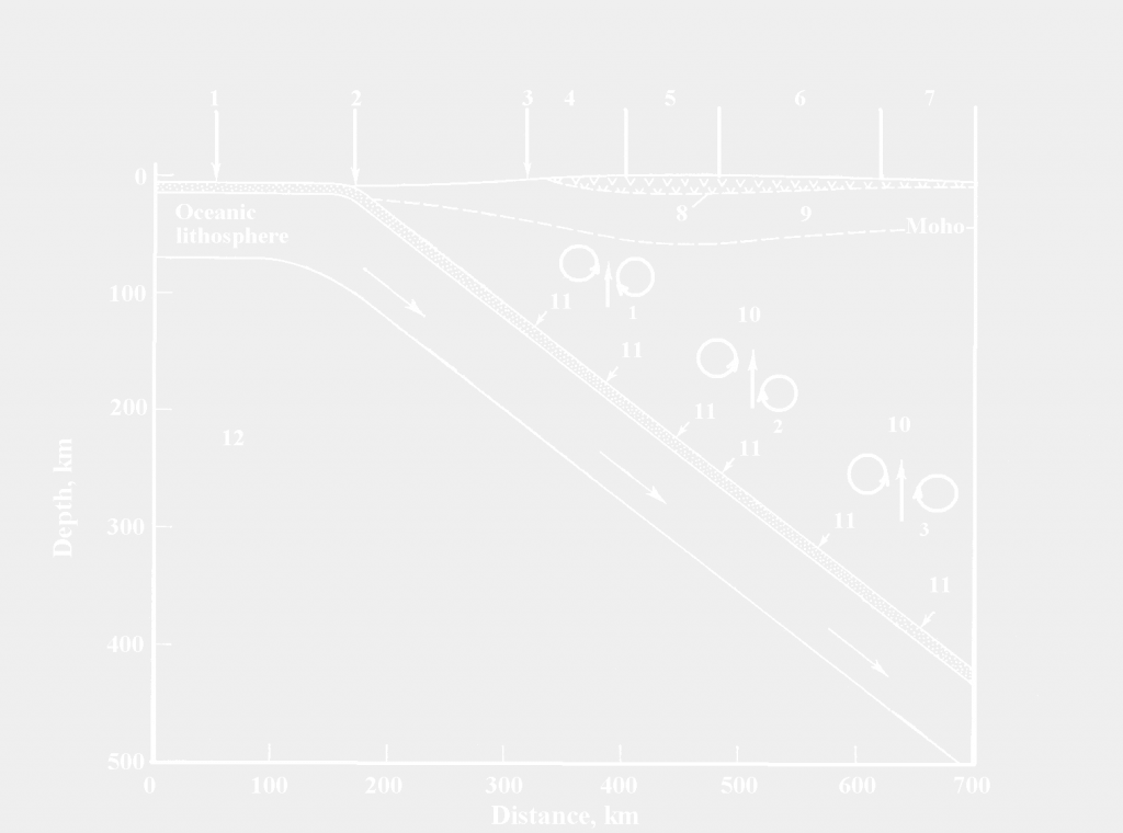
Fig. 1. Schematic deep section of a typical subduction zone showing the surface distribution of the metal provinces (4-7) above the several pairs of the Karig thermodynamic convective vortices (10) over the subducting slab. The metals-containing calcareous-alkaline magmas entrained in the upwelling mantle flows (shown by vertical arrows) provide the formation of the subsurface ore deposits in the Earth’s crust [17]. 1 – oceanic crust and lithosphere; 2 – oceanic trench; 3 – coast of the continental lithospheric plate; 4 – zone of accumulation of iron-containing ores; 5 – zone of accumulation of ores containing gold (Au) and copper (Cu); 6 — zone of accumulation of ores containing silver (Ag), lead (Pb), zinc (Zn); 7 — zone of accumulation of ores containing tin (Sn), molybdenum (Mo); 8 — sedimentary layer; 9 — zone of calcareous-alkaline intrusions (plutons) and volcanic rocks; 10 — zone of rise of calcareous-alkaline magmas and metals contained in them; 11 — partial melting in the absorption zone of oceanic crust layers and metals contained therein; 12 – asthenosphere.
The purpose of this article is to try from the perspective of the concept of lithospheric plate tectonics [12; 14; 17] to explain the origin of some metal provinces of the Far East of the Eurasian plate. Except for the three main lithospheric plates in the Far East of North Asia, viz. the Eurasian, Pacific and North American ones, there are the following plates: the Amur, Okhotsk ones, the concept of the former of which (Amur) was for the first time grounded in [24].
The localization and nature of the boundary between the Amur and Okhotsk Lithospheric Plates became recently a matter of ambiguous and sometimes contradictory debates [18]. According to the latter publication as well as to [6] the Sakhalin island belongs to the active region of North-Eastern Asia, the Sakhalin Island itself being the territory comprising the boundary between the largest lithospheric plates of the Earth, viz. the Eurasian, North-American and Pacific ones. Along the convergent boundaries of these plates there lies a broad boundary zone represented by the Amur, Okhotsk Lithospheric Plates, the two biggest of which (the Amur and Okhotsk ones) being separated by the great Central-Sakhalin (Tym-Poronaysk) fault. Arguments in [20; 21] support the idea of the eastward subduction of Amur Lithospheric Plate under the Okhotsk one with a velocity of ~10 mm per year. According to [10] the Sakhalin Island moves to the west with the velocity of 3 – 4 mm per year with respect to the Eurasian Lithospheric Plate, while the Sakhalin eastward velocity relatively to North America amounts to 3 – 5 mm per year. In [10] the GPS observational data collected in the Far East for over 10 years are as well indicated to support the eastward subduction of the Amur Lithospheric Plate under the Okhotsk one at the fault bisecting the Sakhalin Island. According to seismic data the subduction angle is equal to 36º, however, the abovementioned inter seismic GPS data can be interpreted, although with less grounds, in favor of the western subduction of Okhotsk Lithospheric Plate under the Amur one at an angle of ~ 45º (see Table 1 in [10]). It is worth noting that in [8] the boundary between the Amur and Okhotsk Plates is reported to be “the boundary of ambiguous nature”, while in [16] the boundary between the Amur and Okhotsk Lithospheric Plates is considered to bisect the Sakhalin Island, where numerous shallow micro earthquakes occur. The predominant geological structures there are those corresponding to the tectonics of compression, such as faults and folds of the north – south orientation, directed along the longitudinal axis of the Sakhalin Island. One of the main faults is the Central-Sakhalin one, which is a thrust fault of the meridian orientation, falling down to the west at an angle of approximately 70º. This may be regarded as just another indication by the authors of [8] (and the authors referred to in op. cit.) to the sufficiently steep subduction of the Okhotsk Lithospheric Plate under the Amur one in the western direction.
The goal of the present research is modeling the convective mass- and dissipative heat transfer from the mantle wedge above the subducting Amur Lithospheric Plate to the Earth’s surface. Modeling of the localization and transversal horizontal extent of the 2D zone of anomalous heat flux at the Okhotsk seafloor eastward off the Sakhalin Island (as well as of the heat flux maximum absolute value) allows reliable evidencing in support of the amplitude and eastern direction of the Amur Lithospheric Plate subduction velocity. The model constructed here indirectly confirms the non-Newtonian mantle rheology to predominate in the mantle wedge sufficiently saturated with water, extracted from a subducting lithospheric plate, increasingly compressed in the course of subduction.
According to [2; 4; 5], two types of dissipation-driven small-scale thermal convection in the mantle wedge are possible, viz. the 3D finger-like convective jets, raising to volcanic chain, and the 2D transversal Karig vortices [7], aligned perpendicularly to subduction. These two types of convection are shown to be spatially separated due to the pressure and temperature dependence of mantle effective viscosity, the Karig vortices, if any of them formed, being located behind the volcanic arc [2]. Since there is a lack of unambiguous understanding of the plates subduction in the area of Sakhalin, the present modeling of distribution and absolute value of the anomalous heat flux from the Okhotsk seafloor is all the more important, as it may serve as a decisive argument favoring the eastward subduction of the Amur Lithospheric Plate. Numerical modeling of 2D mantle convection, occurring in the Karig vortices form and transporting dissipative heat, may allow judging about the mean water content in the mantle wedge as well as about the convective transport of mantle hydrocarbons to the Okhotsk seafloor. The model of convection presented here takes into account the temperature and pressure dependence of viscosity and fits best to observations in the case of non-Newtonian rheology for the mean water content of ~ 1 wt. % and subduction velocity of ~ 10 mm per year. In [23] such a great (and even several times greater) water content is indicated as possible to be observed in the transition zone of a mantle wedge.
References
1. Billen M., Hirth G. Newtonian versus non-Newtonian Upper Mantle Viscosity: Implications for Subduction Initiation. Geophys. Res. Lett. 2005. V.32. (L19304). doi: 10.1029/2005GL023458.2. Gavrilov S.V. Investigation of the island arc formation mechanism and the back-arc lithosphere spreading. Geophysical Researches. 2014. V. 15. No. 4. pp. 35–43.
3. Gavrilov S.V., Abbott D.H. Thermo-mechanical model of heat- and mass-transfer in the vicinity of subduction zone. Physics of the Earth. 1999. V.35. No.: 12. pp. 967–976.
4. Gerya T.V. Future directions in subduction modeling. J. of Geodynamics. 2011. V.52. pp. 344-378. doi:10.1016/j.jog.2011.06.005
5. Gerya T.V., Connolly J.A.D., Yuen D.A., Gorczyk W., Capel A.M. Seismic implications of mantle wedge plumes. Phys. Earth Planet. Inter. 2006. V.156. pp. 59-74. doi: 10.1016/j.pepi.2006.02.005
6. Ismail-Zadeh A., Honda S., Tsepelev I. Linking mantle upwelling with the lithosphere decent in the Japan Sea evolution: a hypothesis. Scientific Reports. No. 3. pp. 1137. http://dx.doi.org/101038/srep01137.
7. Karig D.E. Origin and development of marginal basins in the Western Pacific. Journal Geophysical Researches. 1971. V.76. No. 11. pp. 2542-2561. doi: 10.1029/JB076i011p02542
8. Katsumata K., Kasahara M., Ichivanagi M., Kikuchi M., Sen R.-S., Kim Ch.-U., Ivaschenko A., Tatevossian R. The 27 May 1995 Ms 7.6 Northern Sakhalin Earthquake: An Earthquake on an Uncertain Plate Boundary. Bulletin of the Seismological Society of America. 2004. V.94. No. 1. pp. 117 – 130.
9. Khanchuk A.I., Ivanov V.V. Meso-Cenozoic geodynamic conditions and gold mineralization of the Russian Far East. Geology and geophysics. 1999. Vol. 40. No. 11. pp. 1635-1645.
10. Kogan M.G., Burgmann R., Vasilenko N.F., Scholtz C.H., King R.W., Ivashchenko A.I., Frolov D.I., Steblov G.M., Kim Ch.U., Egorov S.G. The 2000 Mw 6.8 Uglegorsk earthquake and regional plate boundary deformation of Sakhalin from geodetic data. Geophys. Res. Lett. 2003. V.30. No.3. pp. 1102 - 1106. doi: 10.1029/2002GL016399.
11. Kogan M.G., Steblov G.M. Current global plate kinematics from GPS (1995 – 2007) with the plate-consistent reference frame. J. Geophys. Res. 2008. V.113. pp. 1 – 17. B04416. doi:10.1029/2007JP.O05353.
12. Noble J. A. Metal provinces and metal finding in the western United States. Bull. Geol. Soc. Am. 1970. V. 81. pp. 1607-1624.
13. Pavlenkova N.I., Kashubin S.N., Gontovaya L.I., Pavlenkova G.A. Deep structure and geodynamics of the Sea of Okhotsk region. Regional geology and metallogeny. 2018. No.76. pp. 70 – 82.
14. Sawkins F.J. Sulfide ore deposits in relation to plate tectonics // Journ. Geol. 1972. V. 80. No. 4. pp. 377-397.
15. Schubert G., Turcotte D.L., Olson P. Mantle Convection in the Earth and Planets. New York: Cambridge University Press, 2001. 940 p.
16. Seno T., Sakurai T., Stein S. Can the Okhotsk plate be discriminated From the North American plate? J. Geophys. Res. V. 101. pp. 11,305–11,315.
17. Sillitoe R.H. Relation of metal provinces in Western America to subduction of oceanic lithosphere. Bull. Geol. Soc. Am. 1972. V. 83. pp. 813-818.
18. Sim L.A., Bogomolov L.M., Bryantseva G.V., Savvishev P.A. Neotectonics and tectonic stresses of the Sakhalin Island. Geodynamics & Tectonophysics. 2017. V.8. No.1. pp.181–202. DOI:105800/GT-2017-8-1-0237.
19. Smirnov Ya.B. (ed.) The Map of the Heat Flux at the Territory of the USSR and Adjacent Regions. Moscow: GUGK. 1980.
20. Sunuwar L, Cuadra C, Karkee M. B. Strong ground motion attenuation in the Sea of Japan (Okhotsk-Amur plates boundary) region. 13-th World Conference on Earthquake Engineering. Vancouver, B.C., Canada. August 1-6, 2004. Paper No. 197.
21. Taira, A. Tectonic evolutions of the Japanese island arc system. Ann. Rev. Earth Planet. Sci. 2001. V. 29. pp. 109-134.
22. Trubitsyn V.P., Trubitsyn A.P. Numerical model of formation of the set of lithospheric plates and their penetration through the 660 km boundary. Physics of the Earth. 2014. No. 6. pp. 138- 147.
23. Zharkov V.N. Physics of the Earth’s Interiors. Duesseldorf: Lambert Academic Publishing. 2019. 438 p.
24. Zonenshain L.P., Savostin L.A. Geodynamics of the Baikal rift zone and plate tectonics of Asia. Tectonophysics. 1981. V. 76. pp. 1 – 45.
25. Yurkova R.M., Voronin B.I. Ascent and transformation of mantle hydrocarbon fluids in connection with a formation of ophiolite diapers. In: “The genesis of hydrocarbon fluids and deposits”. Geos. 2006. pp. 56-67.